2.3 Hillslope Scale
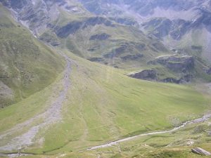
One level below the watershed scale, we find soil spatial patterns at the hillslope scale, roughly 10s to 100s of meters in size. Erosion and deposition help create many of the spatial patterns at this scale. Classic examples are alluvial fans, which are fan-shaped deposits of water transported sediment at the base of hills or mountains. The photograph below provides an aerial view of a well-developed alluvial fan in the French Pyrenees mountains. If you look carefully, you can see the trails perpendicular to the slope created by grazing livestock, indicating focused zones of soil compaction.
Another important hillslope scale pattern commonly recognized by soil scientists is called a catena or toposequence. A catena is a series, or chain, of distinct but related soil types arranged along a hillslope. The soils in a catena typically form from the same parent material but have different physical properties arising from differences in slope, aspect, and drainage. The diagram below represents the Clarion–Nicollet–Webster catena, a common catena found in the highly productive farmland of Iowa and Minnesota in the midwestern United States.
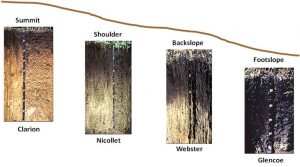
These soils formed in unsorted parent material deposited by prior glaciers, called till, and they differ in drainage with the Clarion soils on the summits being moderately well drained, the Nicollet soils on the shoulder slopes being somewhat poorly drained, and the Webster soils on the backslopes being poorly drained. The Glencoe soils are more limited in extent, very poorly drained, and found in closed depressions. These differences in drainage impact a range of soil properties, for example, soil color and thickness of the A horizon, as seen in the profile photographs.
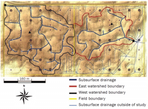
As a result of these hillslope scale soil patterns, many farmers in this region have installed elaborate subsurface drainage systems which remove water from the poorly drained portions of the field in order to improve crop growth. The complex drainage system mapped below drains approximately 129 hectares in western Minnesota, i.e. 320 acres or two quarter sections in the US public land survey system [2]. Notice that many of the drainage pipes have been placed in the low areas and depressions, locations occupied by the more poorly drained soils in the local catena. In this case those soil series are the Parnell and Flom series, both classified as aquolls according to the US soil taxonomy system. The artificial drainage of soils like these greatly increases the crop production potential of the land, but also decreases wetland habitat and increases the risk of contaminating the water bodies receiving the drainage water. To learn about improved drainage water management practices, view this video (link).