12.5 Reference Evapotranspiration
One of the most widespread uses of the surface energy balance concept is for determining evapotranspiration. The actual evapotranspiration rate for a given time for a particular location on the land surface can be substantially influenced by site-specific management practices. Thus, often it is useful to estimate the potential or reference evapotranspiration (ET0) which is the evapotranspiration rate expected for a standard well-watered surface under the prevailing atmospheric conditions. The daily or monthly value of ET0 can be determined for relatively large regions, and those values can be adjusted to estimate actual ET for a specific location if adequate information is available [8]. Methods for estimating ET0 or ET commonly are based on the surface energy balance.
12.5.1 Hargreaves Method
One of the simplest approaches for estimating ET0, the Hargreaves method, was developed to facilitate irrigation management and water planning. The initial work began in California, and the importance of having a simple approach with low data requirements was solidified when the work expanded to Haiti [9]. Building on earlier work in which ET0 was calculated as a linear function of incoming solar radiation (Rs), Hargreaves found that the product of Rs and air temperature (T) explained much of the variance in measured ET0. The problem was that measurements of Rs are often unavailable. Therefore, Hargreaves and colleagues developed a way to estimate Rs from knowledge of extraterrestrial radiation (Ra, solar radiation at the top of Earth’s atmosphere for a specific place and time) and air temperature [10].
Since Ra can be accurately estimated based on site latitude and day of year and air temperature measurements are widely available, the Hargreaves method can be used virtually anywhere. The Hargreaves equation is:
![\[ ET_0=0.0023R_a(\bar{T}+17.8)(T_m_a_x-T_m_i_n)^0^.^5 \]](https://open.library.okstate.edu/app/uploads/quicklatex/quicklatex.com-2e110677938409b8dbc660b85aed8ec6_l3.png "Rendered by QuickLaTeX.com")
(Eq. 12-5)
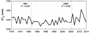
where Ra is the cumulative extraterrestrial radiation for the calculation period converted to units of mm of water, T̄ is the mean temperature (°C) for the calculation period, Tmax is mean daily maximum temperature for the calculation period, and Tmin is mean daily minimum temperature for the calculation period. This equation is designed for use at 5-day or larger calculation periods and is frequently used with monthly calculation periods. The Hargreaves method is a good choice for ET0 estimation when the only meteorological data available are air temperatures. For example, the Hargreaves method was used to estimate a 45-yr time series of ET0 for a large watershed stretching across southwest Oklahoma and part of west Texas, USA (Fig. 12‑7) [11]. Compiling long time series like this would be more difficult, or in some cases impossible, for more data intensive ET0 estimation methods.
12.5.2 Penman-Monteith Method
A more precise approach was for estimating ET was proposed by Penman, who in 1948 combined the equations for the surface energy balance and for turbulent transport of water vapor away from a saturated evaporating surface [12]. In 1965, Monteith expanded the Penman approach to surfaces where the vapor pressure was less than the saturated vapor pressure (i.e. <100% relative humidity) [13]. The Penman-Monteith equation is:
![\[ ET=\frac{1}{L}\frac{\Delta(R_n-G)+\rho_ac_p\frac{e_s-e_a}{r_a}}{\Delta+\gamma\left( 1+\frac{r_s}{r_a}\right)} \]](https://open.library.okstate.edu/app/uploads/quicklatex/quicklatex.com-7ea7b251f5c544e4a19a4e4b7fb92428_l3.png "Rendered by QuickLaTeX.com")
(Eq. 12-6)
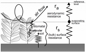
where L is the latent heat of vaporization for water (J kg-1), Rn is the net radiation (W m-2), G is the soil heat flux (W m-2), es – ea is the vapor pressure deficit of the air (kPa), ra is the density of the air (kg m-3), cp is the specific heat capacity of the air at constant pressure (J kg-1 °C-1), Δ is the slope of the relationship between saturated vapor pressure and temperature (kPa °C-1), γ is called the psychrometric constant (kPa °C-1), rs is the surface resistance to vapor transport (s m-1), and ra is the aerodynamic resistance to vapor transport (s m-1). These two resistance terms provide a simplified but effective representation of water vapor transport processes near the land surface (Fig. 12‑8).
A panel of experts from the United Nations Food and Agricultural Organization (FAO) has defined the reference surface as, “A hypothetical reference crop with an assumed height of 0.12 m, a fixed surface resistance of 70 s m-1, and an albedo of 0.23.” [8]. Based on this definition, and employing some approximations for the resistance terms, the FAO Penman-Monteith equation for ET0 is:
![\[ ET_0=\frac{0.408\Delta(R_n-G)+\gamma\frac{900}{(T+273)}u_2(e_s-e_a)}{\Delta+\gamma(1+0.34u_2)} \]](https://open.library.okstate.edu/app/uploads/quicklatex/quicklatex.com-0e2f82b864b088b2177d8bd8066fc5b5_l3.png "Rendered by QuickLaTeX.com")
(Eq. 12-7)
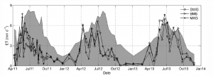
where ET0 is the reference evapotranspiration (mm d-1), Rn and G are in MJ m-2 d-1, T is the mean daily air temperature at 2-m height (°C), and u2 is the mean daily wind speed at 2 m (m s-1). Once ET0 is determined, site- and day-specific “crop coefficients” (Kc) can be estimated to calculate actual ET from ET0, i.e. ET = ET0 × Kc. With judicious use, the FAO Penman-Monteith equation has proven to provide reliable ET0 estimates for use in crops, grasslands, and forests around the world. For example, the FAO Penman-Monteith equation was used to estimate daily ET0 during a 3-yr bioenergy crop experiment in Oklahoma (Fig. 12‑9). The results show that actual ET can be substantially less than ET0 during dry periods (e.g. summers of 2011 and 2012) but can exceed ET0 during wet periods (e.g. summer of 2013) [14].