
2.2 Basin or Watershed Scale
At the scale of a river basin or watershed, typically 10s to 100s of kilometers, the spatial patterns in soil properties can be so large that we fail to recognize them. We may only travel a few kilometers from our home in a typical day, or if we travel farther, we may not take the time to notice the changes in the soil around us. Yet, these large spatial patterns can have significant impacts on human communities and on ecosystems.
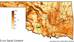
Consider the map below which shows the estimated sand content of the surface soils across the state of Oklahoma, USA. Some of the striking patterns we can see are the dark brown bands of high sand content trending northwest to southeast in the northwestern part of the state. These sandy areas follow along the north side of rivers such as the Cimarron River and the North Canadian River and overlie alluvial aquifers which provide groundwater for irrigation and for municipal use by several Oklahoma communities. The windblown sands were likely deposited along the north sides of these rivers by the prevailing south winds during past severe drought events which denuded the landscape. These soil patterns help explain a variety of social and ecological characteristics from the economies of rural communities to the distributions of native plant species on the landscape.
