
4.1 Defining Nation-States
Organization and Control
Political geography is the study of how humans have divided up the surface of the Earth for purposes of management and control. Looking beyond the patterns on political maps helps us to understand the spatial outcomes of political processes and how political processes are themselves affected by spatial features. Political spaces exist at multiple scales, from a kid’s bedroom to the entire planet. At each location, somebody or some group seeks to establish the rules governing what happens in that space, how power is shared (or not), and who even has the right to access those spaces. This is also known as territoriality.
Many people have tried to exert control over the physical world to exert power for religious, economic, or cultural reasons. Scholars have developed many theories of how political power has been expressed geographically as leaders and nations vie to control people, land, and resources. In the late 1800s and early 1900s, scholars developed many theories about how political power is expressed geographically. These theories have been used to both justify and work to avoid conflict.

Organic Theory
The Organic Theory states that nations must continually seek nourishment in the form of gaining land to survive in the same way that a living organism seeks nourishment from food to survive. As a result, it implies that if a nation does not seek out and conquer new territories, it will risk failing because other nations also behave organically. This is akin to the law of the jungle – eat or be eaten.
Hitler was a proponent of organic theory and used Raztel’s term Lebensraum or “living space” as justification for Germany’s behavior during World War II. He claimed that if Germany did not grow in this way, it would fall victim again to the rest of Europe and eventually the world as it did during the First World War.
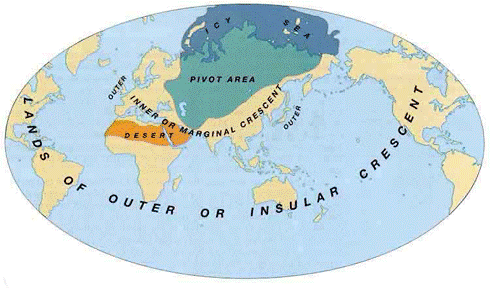
Heartland Theory
Heartland Theory, also known as “The Geographic Pivot of History” theory, Mackinder thought that whoever controlled Eastern Europe, the heartland, would control the world. The idea is that the heartland is a pivot point for controlling all of Asia and Africa, which he referred to as the World Island. Why was the heartland so crucial at this time? Eastern Europe is abundant in raw materials and farmland, which are needed to support a vast army that could then control the coasts and water ports that make international trade possible.
Both Hitler and the USSR believed this was possible, but both failed because they did not foresee the rise of other world powers such as the United States and China. Nor did they know that military technology would soon advance far beyond tanks and ground troops to include nuclear weapons, high-tech missiles, and drone airplanes.
Rimland Theory
According to Spykman’s Rimland Theory, Mackinder’s “lands of the outer rim” were the key to controlling Eurasia and then the world. He theorized that because the Rimland contains most of the world’s people as well as a large share of the world’s resources, it was more important than heartland. The Rimland’s defining characteristic is that it is an intermediate region, lying between the heartland and the marginal sea powers. As the amphibious buffer zone between the land powers and sea powers, it must defend itself from both sides, and therein lies its fundamental security problems.
Politically, Spykman called for the consolidation of the Rimland countries to ensure their survival during World War II. With the defeat of Germany and the emergence of the USSR, Spykman’s views were embraced during the formulation of the Cold War American policy containing communist influence.
The State of States
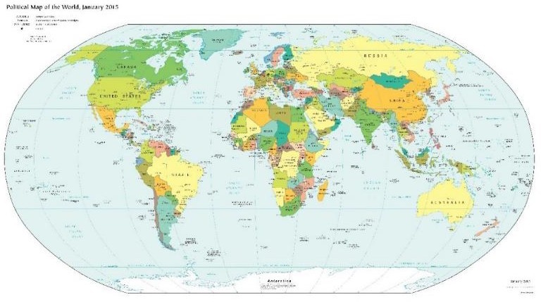
Independent states are the primary building blocks of the world political map. A state (also called a nation or country) is a territory with defined boundaries organized into a political unit and ruled by an established government that has control over its internal and foreign affairs. When a state has total control over its internal and foreign affairs, it is called a sovereign state. A location claimed by a sovereign state is called a territory. According to the United Nations, in 2016, the world had 193 nations; however, many of those nations dispute their boundaries.
Some nations are stateless. This means that there are groups of people who share a collective identity and history, but who have no parcel of land that they fully control. The Palestinians are perhaps the world’s best-known stateless nation, owed to their long struggle with Israeli Jews – some of whom, until 1948, belonged to the previously best-known nation without a state.
Federalism is a system of government with one, strong, central governing authority as well as smaller units, such as states. If the central government grows too strong, then federalism comes closer to a unitary state, where the governing body has supreme authority and dictates how much power the units are allowed to have. In those places like Egypt, France, and Japan, where nationalist feelings are strong, and there are many centripetal forces like language, religion, and economic prosperity uniting people, a unitary state makes much sense. Unitary systems work best where there is no strong opposition to central control. Therefore, the political elite in a capital city (like Paris or Tokyo) frequently have outsized power over the rest of the country. Fights over local control are minimal, and the power of local (provincial) governments is relatively weak.
Many countries have an underdeveloped sense of nationhood and therefore are better suited to use a Federalist style of government where power is geographically distributed among several subnational units. This style of governance makes sense when a country is “young” – and is still in the process of nation-building or developing a common identity necessary to the establishment of a unified nationality. Federations may also work best when nations have multi-ethnic or multi-national countries. Rather than break into multiple smaller states, a country can choose to give each of its ethnicities or nationalities some measure of political autonomy. If they want to speak their language or teach their specific religion in the local schools, then the central government allows local people to make those decisions. The central government in a federal system focuses on things like national defense, managing interstate transportation, and regulating a common currency. The U.S. began as a federalist system.
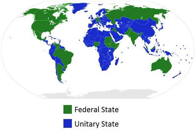
Occasionally, a particularly troublesome provincial region or ethnicity will result in a sort of compromise situation, or devolution, in which a unitary system, like China, will grant a special exemption to one region or group to allow that location semi-autonomy or greater local control. Puerto Rico (United States) and Hong Kong (China) are excellent examples. However, there are many dozens of other similarly self-governing regions around the globe, most with names designating their status. This process is often beneficial to the unitary nations to prevent political instability and conflict; however, it can be withdrawn by the central government at any time.
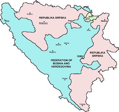
The hostile fragmentation of a region into smaller, political units is called Balkanization. This is often the result of unresolved centrifugal forces pulling the nation apart from within, such as economic disparity and ethnic or religious conflicts. The term Balkanization refers to an area that was known as the Ottoman Empire, and it occupied the area where we have current countries like Bulgaria, Albania, and Serbia. Nowadays, we use this term to refer to any country that breaks apart to form several countries or several states, usually the consequence of civil war or ethnic cleansing as was seen in Armenia and Azerbaijan, Bosnia and Herzegovina and Croatia and Yugoslavia.
The United States has had a challenging time resolving whether it wants to pursue a unitary or federal style government. This question has been one of the central political issues in the U.S., since even before the War for Independence. Initially, the United States was organized as a confederation, a loosely allied group of independent states united in a common goal to defeat the British. Operating under the Articles of Confederation from roughly 1776-1789, the new and decentralized country found itself challenged to do simple things like raise taxes, sign treaties with foreign countries, or print a common currency because the central government (Congress) was so very weak. The Constitution that the U.S. Government, operates under today was adopted to help create a balance of powers between the central government headquartered in Washington DC, and the multiple state governments. Initially, states continued to operate primarily as separate countries. This is why, in the United States, the word state is used to designate major subnational government units, rather than the word province, as is common in much of the world. In our early history, Americans thought they were living in “The United Countries of America.”
The idea or concept of a state originated in the Fertile Crescent between the Persian Gulf and the Mediterranean Sea. The first ancient states that formed during this time were called city-states. A city-state is a sovereign state that encompasses a town and the surrounding landscape. Often, city-states secured the town by surrounding it with walls, and farmlands were located outside of the city walls. Later, empires formed when a single city-state militarily controlled several city-states.
The agrarian revolution and the Industrial Revolution were powerful movements that altered human activity in many ways. Innovations in food production and the manufacturing of products transformed Europe, and in turn, political currents were undermining the established empire mentality fueled by warfare and territorial disputes. The political revolution that transformed Europe as a result of various actions that focused on ending continual warfare for the control of territory and introducing peaceful agreements that recognized the sovereignty of territory ruled by representative government structures. Various treaties and revolutions continued to shift the power from dictators and monarchs to the general populace. The Treaty of Westphalia in 1648 and those that followed helped establish a sense of peace and stability in Central Europe, which had been dominated by the Holy Roman Empire and competing powers. The Holy Roman Empire, which was centered on the German states of Central Europe from 962–1806, should not be confused with the Roman Empire, which was based in Rome and ended centuries earlier. The French Revolution (1789–95) was an example of the political transformation taking place across Europe to establish democratic processes for governance.
The concept of the modern nation-state began in Europe as a political revolution laid the groundwork for a sense of nationalism: a feeling of devotion or loyalty to a specific nation. The term nation refers to a homogeneous group of people with a common heritage, language, religion, or political ambition. The term state refers to the government; for example, the United States has a State Department with a Secretary of State. When nations and states come together, there is a true nation-state, wherein most citizens share a common heritage and a united government.
European countries have progressed to the point where the concept of forming or remaining a nation-state is a driving force in many political sectors. To state it plainly, most Europeans, and to an extent every human, want to be a member of a nation-state where everyone is alike and shares the same culture, heritage, and government. The result of the drive for nation-states in Europe is Italy for Italians, a united Germany for Germans, and France for the French, for example. The truth is that this ideal goal is challenging to come by. Though the political boundaries of many European countries resemble nation-states, there is too much diversity within the nations to consider the idea of creating a nation-state an actual reality.
After the concept of the nation-state had gained a foothold in Europe, the ruling powers focused on establishing settlements and political power around the world by imposing their military, economic, political, and cultural influence through colonialism. Colonialism is the control of previously uninhabited or sparsely inhabited land. Europeans used colonialism to promote political control over religion, extract natural resources, increase economic influence, and to expand political and military power. The European states first colonized the New World of the Americas, but later redirected their focus to Africa and Asia. This colonial expansion across the globe is called imperialism.
Imperialism is the control of territory already occupied and organized by an indigenous society. These two factors helped to spread nationalism around the globe and have influenced modern political boundaries.
The Shape of States
While not the only factor in determining the political landscape, the shape of a state is important because it helps determine potential communication internally, military protection, access to resources, and more. Find the example listed on a political map and try to find one other state that has the same physical shape.
- Compact states have relatively equal distances from their center to any boundary, much like a circle. They are often regarded as efficient states. An example of a compact state would be Kenya.
- Elongated states have a long and narrow shape. The major problem with these states is with internal communication, which causes isolation of towns from the capital city. Vietnam is an example of this.
- Prorupted states occur when a compact state has a portion of its boundary extending outward exceedingly more than the other portions of the boundary. Some of these types of states exist so that the citizens can have access to a specific resource, such as a large body of water. In other circumstances, the extended boundary was created to separate two other nations from having a common boundary. An example of a prorupted state would be Namibia.
- Perforated states have other state territories or states within them. A great example of this is Lesotho, which is a sovereign state within South Africa.
- Fragmented states exist when a state is separated. Sometimes large bodies of water can fragment a state. Indonesia is an example of a fragmented state.
- Landlocked states lack a direct outlet to a major body of water, such as a sea or ocean. This becomes problematic specifically for exporting trade and can hinder a state’s economy. Landlocked states are most common in Africa, where the European powers divided up Africa into territories during the Berlin Conference of 1884. After these African territories gained their independence and broke into sovereign states, many became landlocked from the surrounding ocean. An example here would be Uganda.
Boundaries
Boundaries are often divided into two categories: (1) natural – following the course of a physical feature such as a river or ridgeline; (2) artificial – drawn by humans. However, so-called natural boundaries are still products of human choice — why establish that river, rather than this other one, as the boundary? Moreover, the political border may persist even after the physical feature, which created the original boundary has changed its location. Thus, the boundaries of states bordering the Mississippi River are fixed to the river’s old course, though the location of its meanders has changed.
Boundaries play a critical role in how people interpret the world around them and can often be sources of conflict at all scales, from two neighbors arguing over where a fence should be placed to nation-states laying claim to parts of (or sometimes all) other sovereign nations. The Atlantic has an article titled, “The Case for Getting Rid of Borders – Completely” that argues that morally and ethically, people should have more equal rights no matter which nation-state they belong to.
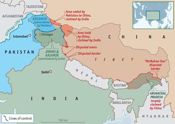
It is important to look at how political boundaries are created, determined, and occasionally redrawn. Consider the case of Kashmir, a territory disputed between India and Pakistan. Within India, publishers are required to show Kashmir as part of India. In 2011, the Indian government ordered the Economist magazine to remove or cover such a map in 28,000 copies of its May edition which were for sale in India. Even well-known multi-national companies like Google Maps are censored if they show the area as “disputed.” This means that Indians grow up always seeing Kashmir as a part of their country, of equal standing with undisputed states like Tamil Nadu or Assam. Any proposal to recognize Pakistani control over part or all of Kashmir would then provoke severe resistance from the Indian populace. Maps outside the disputant countries commonly show both boundaries, noting their disputed status. However, this compromise is not neutral, as it sends a message that both claims are equally legitimate. Imagine, for example, if Canada announced a claim to Washington State, and maps published outside North America began showing that state as a disputed territory.
Another interesting question comes up when learning about boundaries, “Who owns the sea?” A maritime boundary is a conceptual division of the Earth’s water surface areas. As such, it usually defines areas of exclusive national rights over any natural resources within that boundary. A maritime boundary is delineated at a particular distance from the coastline. Although in some countries, the United Nations Convention on the Law of the Sea defines the boundary of international waters.
Controversies about territorial waters tend to encompass two dimensions: (a) territorial sovereignty, which is a legacy of history, and (b) relevant jurisdictional rights and interests in maritime boundaries, which are mainly due to differing interpretations of the law of the sea. Many disputes have been resolved through negotiations, but not all.
For instance, The Strait of Juan de Fuca is the wide waterway stretching from the Pacific Ocean on the West to the San Juan Islands on the east, with Vancouver Island to the north and the Olympic Peninsula to the south. This strait remains the subject of a maritime boundary dispute between Canada and the United States. The dispute is only over the seaward boundary extending 200 miles (320 km) west from the mouth of the strait. Both governments have proposed a boundary based on the principle of equidistance, but with different base point selections, resulting in small differences in the line. Also, the government of British Columbia has rejected proposals by the United States, instead of arguing that the Juan de Fuca submarine canyon is the appropriate “geomorphic and physio-geographic boundary.” The resolution of the issue should be simple but has been hindered because it might influence other unresolved maritime boundary issues between Canada and the United States around the Gulf of Maine.
Theories of a State
State Formation and the Centralization of Power
Today we take it for granted that different societies are governed by different states, but this has not always been the case. Since the late nineteenth century, virtually the entirety of the world’s inhabitable land has been parceled up into areas with more or less definite borders claimed by various states. Earlier, quite large land areas had been either unclaimed or uninhabited, or inhabited by nomadic peoples who were not organized as states. In fact, for most of human history, people have lived in stateless societies, characterized by a lack of concentrated authority, and the absence of significant inequalities in economic and political power.
The first known states were created in Ancient Egypt, Mesopotamia, India, China, the Americas (e.g., Aztec civilization, Inca civilization). Most agree that the earliest states emerged when agriculture and writing made it possible to centralize power durable. Agriculture allowed communities to settle and also led to class division: some people devoted all their time to food production, while others were freed to specialize in other activities, such as writing or ruling. Thus, states, as an institution, were a social invention. Political sociologists continue to debate the origins of the state and the processes of state formation.
Most political theories of the state can roughly be classified into two categories. The first, which includes liberal or conservative theories, treats capitalism as a given and concentrates on the function of states in a capitalist society. Theories of this variety view the state as a neutral entity distinct from both society and the economy.
Marxist Theory
Marxist theory, on the other hand, sees politics as intimately intermingled with economic relations, and emphasizes the relationship between economic power and political power. Marxists view the state as a partisan instrument that primarily serves the interests of the upper class. Marx and Engels were clear that communism’s goal was a classless society in which the state would have “withered away. ” For Marxist theorists, the role of the non-socialist state is determined by its function in the global capitalist order. Marx’s early writings portrayed the state as “parasitic,” built upon the superstructure of the economy and working against the public interest. He believed that the state mirrored societal class relations, that it regulated and repressed class struggle, and that it was a tool of political power and domination for the ruling class.
Anarchism
Anarchism is a political philosophy that considers states immoral and instead promotes a stateless society, anarchy. Anarchists believe that the state is inherently an instrument of domination and repression, no matter who is in control of it. Anarchists believe that the state apparatus should be dismantled entirely and an alternative set of social relations created, which would be unrelated to state power.
https://www.youtube.com/watch?v=JM0_0pfm2_c
Pluralism
Pluralists view society as a collection of individuals and groups competing for political power. They then view the state as a neutral body that enacts the will of whichever group dominates the electoral process. Within the pluralist tradition, Robert Dahl developed the theory of the state as a neutral arena for contending interests. He also viewed governmental agencies as merely another set of competing interest groups. The pluralist approach suggests that the modern democratic state acts in response to pressures that are applied by a variety of related interests. Dahl called this kind of state a polyarchy. Pluralism has been challenged on the ground that it is not supported by empirical evidence.
Hydraulic Civilization
According to one early theory of state formation, the centralized state was developed to administer large public works systems (such as irrigation systems) and to regulate complex economies. This theory was articulated by German American historian Karl August Wittfogel in his book 1957 Oriental Despotism. Wittfogel argued that most of the earliest states were formed in hydraulic civilizations, by which he meant civilizations where leaders controlled people by controlling the water supply. Often, these civilizations relied on complex irrigation systems that had to be centrally managed. The people, therefore, had good reason to give control to a central state, but in giving up control over the irrigation system, they also gave up control over their livelihoods and, thus, the central state gained immense control over people in general. Although Wittfogel’s theory is well known, it has also been criticized as inaccurate. Modern archaeological and anthropological evidence shows that many early societies were not as centralized, despotic, or unequal as the hydraulic theory would suggest.
Coercion, War, and the State
An alternative theory of state formation focuses on the rise of more modern nation-states and explains their rise by arguing they became necessary for leveraging the resources necessary to fight and defend against wars. Sociologist Charles Tilly is the best-known theorist in this tradition. Tilly examined the political, social, and technological change in Europe from the Middle Ages to the present and attempted to explain the unprecedented success of the nation-state as the dominant form of state on Earth. In other words, instead of asking (like Wittfogel) where the very first states came from, Tilly asked where the types of states with which we are most familiar came from, and why they became so prevalent.
According to Tilly’s theory, military innovation in pre-modern Europe (especially gunpowder and mass armies) made war extremely expensive. As a result, only states with a sufficient amount of capital and a large population could afford to pay for their security and ultimately survive in a hostile environment. Thus, the modern states and their institutions (such as taxes) were created to enable war-making.
Rationalization and Bureaucracy
Another theory of state formation focuses on the long, slow, process of rationalization and bureaucratization that began with the invention of writing. The Greeks were the first people known to have explicitly formulated a political philosophy of the state, and to have rationally analyzed political institutions. In Medieval Europe, feudalism furthered the rationalization and formalization of the state. Feudalism was based on the relationship between lord and vassal, which became central to social organization and, indeed to the state organization. The Medieval state was organized by Estates, or parliaments in which key social groups negotiated with the king about legal and economic matters. Since then, states have continued to grow more rational and bureaucratic, with expanding executive bureaucracies, such as the extensive cabinet system in the United States. Thus, states have evolved from relatively simple but powerful central powers to sophisticated and highly organized institutions.
https://www.youtube.com/watch?v=EUzRNp7OucQ
